

Economic Impact Volunteering
What is the Economic Impact Survey (EIS)?
The EIS is designed to calculate the scale of the benefits that climbing brings to the local economy. Showing the value of climbing will help us protect access and rally support for improved infrastructure in climbing areas, better transport, and improved services for visiting climbers. It will also give us data that can be used as a benchmark when we repeat this sort of study 5 or 10 years down the line.
How you can help:
We need volunteers to help us gather the data. There are two roles - counting climbers, and surveying them. Counting climbers helps us create an estimate for how many people are out on the rocks over the course of a year. Surveying them helps us understand their spending patterns.
Counting climbers:
You will be given a map of a specific route designed to cover the entire climbing area you have chosen. We will also provide GPX tracks for them which you can follow on your phone. It’s important to follow the designated route to make sure that our counts are consistent. Routes take between 1.5-2hrs.
Interviewing climbers:
You will be provided with paper surveys and some guidance on how to carry out interviews. We aim for around 1.5-2 hours of surveying. Surveying typically takes place in the parking lot or the entrance to an area. We prefer to survey people after they have climbed when they aren’t rushing to get to the crag, so it’s best to avoid signing up for first thing in the morning.
Sign Up Now
You can use the form linked below to sign up for any day and location that suits you. Please try to give us ~12hrs notice so we can send you instructions. When you sign up, an event will be created in the embedded calendar. Before filling out the form, make sure no one is already covering that location on the same day. Surveys on consecutive days are still valuable, particularly if one is a weekend and one is a weekday, or if weather conditions are different.
Count Location Details
All of the count routes are designed to comprehensively cover the area. You can see maps, distances, and estimated time taken for each of them below.
Murrin Park
4.5km, 315m elevation gain. 1.5-2hrs

Shannon Falls
4km, 300m elevation gain. 1.5 hrs.

Grand Wall/Apron Boulders
2.5km, 50m elevation gain. 1-1.5 hrs.


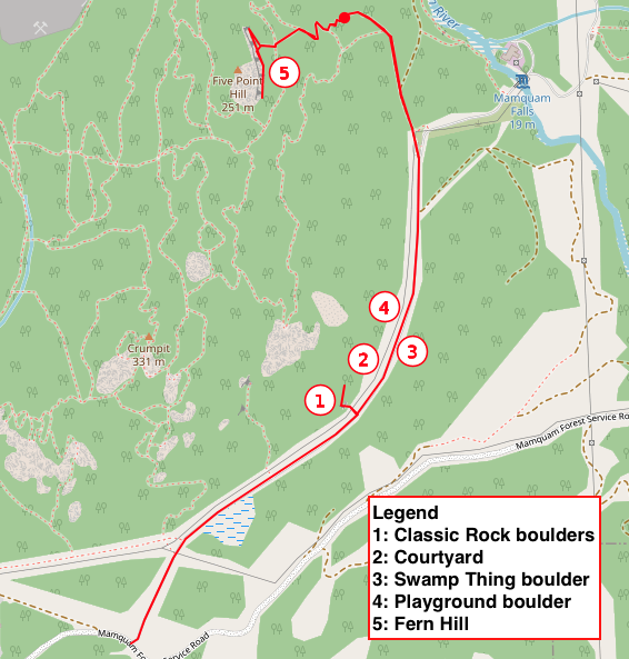
Fern Hill
1.9km in car/on bike, 2km on foot. 150m elevation gain. 45 minutes.
Smoke Bluffs
4.9km, 315m elevation gain. 1.5-2hrs.

Paradise Valley
2.8km, 250m elevation gain. 1.5 hrs.

Brohm Lake
1.4km, 100m elevation gain. 45 minutes.

Cheakamus Canyon
5.3km, 380m elevation gain. 2.5 hrs. Includes some scrambling and exposure. Also includes a short drive to cover the Hideout crag, which is accessed from the salt sheds just past the main Chek turnoff at Conroy Creek FSR.
